[64 / 11 / ?]

63KiB, 524x640, 279055623_356256706539299_3744283539184521125_n.jpg
Quoted By: >>20130048 >>20130050 >>20130051 >>20130052 >>20130054 >>20130062 >>20130068 >>20130069 >>20130077 >>20130088 >>20130091
>The Tuatha de Danaan were a royal bloodline who migrated to Ireland from Scythia, where they were known as Tuadhe d’Anu, and before that from the Armenian Highlands as Anu-naki, People of Anu.
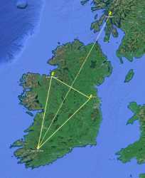
>Three of the most important ritual sites in ancient Ireland were Knocknarea, Tara, and a ritual complex at the foot of the Paps of Anu.
>In historical times the Tuatha became the foundation of the Scots-Gael kings and Queens, who then moved the seat of power from Tara to Dunadd in Scotland, where they congregated in a round court. >Since the Tuatha were fair skinned they were known as the ‘fair folk’, and the circular courts became ‘fairy rings’.
>The three Irish sites form a near-perfect isosceles triangle. Bisect the triangle and you reach the fairy ring on the summit of Dunadd.
Now the big question: how did they achieve this without satellites, GPS or large-scale map-making technology?
