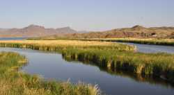
I went on a backpacking trip which crossed the Bill Williams (east of the refuge) last year. Really surprised me how lush it was. Took more than an hour just to fight through the brush on the banks and then had to wade through thigh deep flowing water with quicksand at the bottom, honestly felt a little sketchy doing that alone in such a remote place when I have like no river crossing experience (bc Arizona) but I survived and it's fucking beautiful out there. Big green cottonwoods, lots of wildlife, spooky abandoned ranches, and some of the most unique canyons I've found in the Sonoran Desert. I guess most rivers here were like that before colonization but I really wasn't expecting such an intact riparian zone on a dammed river in some of the driest country I'd ever seen. Can post pics later if people are interested.
Anyway to answer your question OP, most perennial rivers in the Southwest US were like that before colonization. Once US industry got their hands on the region they built a lot of dams and pumped groundwater which changed the ecosystem dramatically (recommend Killing the Hidden Waters by Charles Bowden for more on this). Today a lot of them are dry or only run a few weeks each year. The most direct comparison to the Nile in terms of size, ecosystem, and regional importance is probably the Colorado river, especially the lower section along the CA/NV/AZ border.

